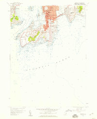
1957 Map of Newport
USGS Topo · Published 1959About this map
Newport’s dense coastal architecture and historic Gilded Age estates define this late-1950s survey of Aquidneck Island and Conanicut Island. The map meticulously details the urban core around Newport Harbor, showing the proximity of religious and educational landmarks like Trinity Ch and Salve Regina College to the sprawling military grounds of Fort Adams and the U S Naval Res.
Find a feature on this map
75 named features on this map. Tap any name to fly to it.
Don’t see what you’re looking for? This feature index may not catch every label — zoom into the map to look around manually.
Map Details
Editions of this 1957 Newport Map
4 editions found
Other maps of this area

1885 · Sakonnet
USGS Topo · 1:62,500

1888 · Fall River
USGS Topo · 1:62,500

1888 · Sakonnet
USGS Topo · 1:62,500

1889 · Newport
USGS Topo · 1:62,500

1890 · Narragansett Bay
USGS Topo · 1:62,500

1892 · Narragansett Bay
USGS Topo · 1:62,500

1893 · Sakonnet
USGS Topo · 1:62,500

1893 · Fall River
USGS Topo · 1:62,500

1894 · Newport
USGS Topo · 1:62,500

1904 · Newport
USGS Topo · 1:62,500