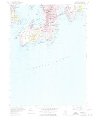
1957 Map of Newport
USGS Topo · Published 1977About this map
Newport's complex coastline and storied maritime architecture are captured here, reflecting the city’s post-war transition into a modern coastal hub while preserving its deep historical roots. The map details the dense urban core on Newport Neck, where landmarks like Trinity Ch and the Common Ground Cem stand alongside educational institutions like Salve Regina College and De La Salle Academy. The defensive legacy of the harbor is anchored by the sprawling Fort Adams and the U.S. Naval Reservation across the water on Conanicut Island. Along the southern shore, Ocean Drive winds past legendary coastal features such as Spouting Rock, Price Neck, and Gooseberry Island, illustrating the area's development as a premier residential and recreational destination. Across the Narragansett Bay East Passage, the quieter landscape of Jamestown and The Dumplings provides a striking contrast to the bustling city harbor.
Find a feature on this map
107 named features on this map. Tap any name to fly to it.
Don’t see what you’re looking for? This feature index may not catch every label — zoom into the map to look around manually.
Map Details
Editions of this 1957 Newport Map
4 editions found
Other maps of this area

1885 · Sakonnet
USGS Topo · 1:62,500

1888 · Fall River
USGS Topo · 1:62,500

1888 · Sakonnet
USGS Topo · 1:62,500

1889 · Newport
USGS Topo · 1:62,500

1890 · Narragansett Bay
USGS Topo · 1:62,500

1892 · Narragansett Bay
USGS Topo · 1:62,500

1893 · Sakonnet
USGS Topo · 1:62,500

1893 · Fall River
USGS Topo · 1:62,500

1894 · Newport
USGS Topo · 1:62,500

1904 · Newport
USGS Topo · 1:62,500