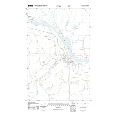
2011 Map of Newport
USGS Topo · Published 2011About this map
The Pend Oreille River serves as the central artery for this borderland, where the city of Newport meets its Idaho neighbor, Oldtown. This survey illustrates the intricate relationship between the river and the regional economy, dominated by hydraulic control and mineral extraction. Albeni Falls Dam and Willy-O Lake Dam regulate the local waters, while the Bodie Canyon Mine stands as a marker of the area's resource-driven history on the slopes of Cooks Mountain.
Find a feature on this map
107 named features on this map. Tap any name to fly to it.
Don’t see what you’re looking for? This feature index may not catch every label — zoom into the map to look around manually.
Map Details
Editions of this 2011 Newport Map
This is the sole edition of this map. No revisions or reprints were ever made.
Other maps of this area

1901 · Sandpoint
USGS Topo · 1:125,000

1911 · Priest Lake
USGS Topo · 1:250,000

1911 · Sandpoint
USGS Topo · 1:125,000

1913 · Priest Lake
USGS Topo · 1:250,000

1936 · Newport
USGS Topo · 1:96,000

1942 · Newport
USGS Topo · 1:125,000

1958 · Sandpoint
USGS Topo · 1:250,000

1963 · Sandpoint
USGS Topo · 1:250,000

1967 · Quartz Mtn
USGS Topo · 1:24,000
1968 · Blanchard
USGS Topo · 1:24,000