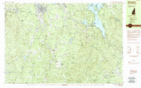
1984 Map of Newport
USGS Topo · Published 1984About this map
Newport serves as the primary hub on the upper Sugar River during this mid-1980s survey, where the Boston and Maine RR winds through the river valley connecting smaller hamlets like Kelleyville and Guild. The landscape is dominated by the massive terrain of Mount Sunapee State Park, featuring the high-elevation Lake Solitude and the South Peak of the mountain. Long-distance recreation is evident through the Monadnock-Sunapee Greenway Trail and the Pillsbury-Sunapee Corridor, which bridge the gap between Sunapee and Pillsbury State Park to the south.
Find a feature on this map
90 named features on this map. Tap any name to fly to it.
Don’t see what you’re looking for? This feature index may not catch every label — zoom into the map to look around manually.
Map Details
Editions of this 1984 Newport Map
2 editions found
Other maps of this area

1902 · Sunapee
USGS Topo · 1:62,500

1905 · Sunapee
USGS Topo · 1:62,500

1907 · Sunapee
USGS Topo · 1:62,500

1926 · Hillsboro
USGS Topo · 1:62,500

1926 · Claremont
USGS Topo · 1:62,500

1927 · Bellows Falls
USGS Topo · 1:48,000

1928 · Mount Kearsarge
USGS Topo · 1:62,500

1929 · Claremont
USGS Topo · 1:62,500

1929 · Hillsboro
USGS Topo · 1:62,500

1930 · Lovewell Mountain
USGS Topo · 1:62,500