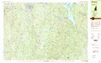
1984 Map of Newport
USGS Topo · Published 1984About this map
Newport serves as the primary hub in this mid-1980s survey, situated where the Sugar River meets its South Branch. The landscape is defined by the high peaks of Mount Sunapee State Park, which separate the river valleys from the expansive Sunapee Lake. This map captures a distinct network of small settlements and hamlets, including Guild, Goshen, and Newbury, many of which developed around the region's historic rail and water resources. The presence of Sunapee Station and Blodgett Landing points to the area's long-standing role as a destination for transportation and recreation. To the south, protected lands like Pillsbury State Park are linked by the Monadnock-Sunapee Greenway Trail, illustrating a conservation corridor that preserves the character of the Sullivan County highlands. Genealogists can find numerous family-named landmarks such as Thatcher Hill, Gunnison Road, and Babb Hill scattered throughout the rural townships.
Find a feature on this map
82 named features on this map. Tap any name to fly to it.
Don’t see what you’re looking for? This feature index may not catch every label — zoom into the map to look around manually.
Map Details
Editions of this 1984 Newport Map
2 editions found
Other maps of this area

1902 · Sunapee
USGS Topo · 1:62,500

1905 · Sunapee
USGS Topo · 1:62,500

1907 · Sunapee
USGS Topo · 1:62,500

1926 · Hillsboro
USGS Topo · 1:62,500

1926 · Claremont
USGS Topo · 1:62,500

1927 · Bellows Falls
USGS Topo · 1:48,000

1928 · Mount Kearsarge
USGS Topo · 1:62,500

1929 · Claremont
USGS Topo · 1:62,500

1929 · Hillsboro
USGS Topo · 1:62,500

1930 · Lovewell Mountain
USGS Topo · 1:62,500