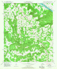
1947 Map of Newsome Sinks
USGS Topo · Published 1967About this map
The Huntsville Meridian serves as a primary north-south anchor for this 1946 aerial survey, cutting through the rugged highlands where Morgan and Marshall counties meet. This landscape is defined by its deep coves and high ridges, including Bettinger Mtn and Pritchett Mountain, which hem in small rural settlements. Community life at the time centered on a network of country churches and schools, such as Pine Ridge Church, Mt Olive Church, and Greenbriar Cove School. To the north, the Tennessee River expands into Wheeler Lake, a product of early 20th-century damming that reshaped the riverine economy near Clarksville Landing. Genealogists will find a wealth of family history in the many small burial grounds scattered across the terrain, including Saints Cem, Rescue Cem, and Skidmore Cem, alongside landmarks like Norrell Sink and Ballew Point.
Find a feature on this map
66 named features on this map. Tap any name to fly to it.
Don’t see what you’re looking for? This feature index may not catch every label — zoom into the map to look around manually.
Map Details
Editions of this 1947 Newsome Sinks Map
3 editions found
Other maps of this area

1885 · Gadsden
USGS Topo · 1:125,000

1888 · Cullman
USGS Topo · 1:125,000

1888 · Gadsden
USGS Topo · 1:125,000

1888 · Scottsboro
USGS Topo · 1:125,000

1888 · Huntsville
USGS Topo · 1:125,000

1892 · Cullman
USGS Topo · 1:125,000

1892 · Huntsville
USGS Topo · 1:125,000

1892 · Scottsboro
USGS Topo · 1:125,000

1892 · Gadsden
USGS Topo · 1:125,000

1895 · Gadsden
USGS Topo · 1:125,000