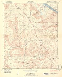
1950 Map of Newsome Sinks
USGS Topo · Published 1950About this map
Wheeler Reservoir and the Tennessee River dominate the northern landscape of this Marshall County borderland, where the Huntsville Meridian serves as a primary survey anchor. The terrain is defined by the unique karst topography of the Newsome Sinks and the steep elevations of Benton Mountain and Guillon Mtn. Small agricultural settlements like Morgan City and Rescue are connected by a network of winding roads that follow the hollows and gaps, such as Saylor Gap and Light Gap. Local life in the mid-century is marked by numerous rural institutions, including Pine Ridge Church and the New Horton School. The map also documents many family burial grounds, such as Saints Cem and Prince Cem, alongside natural landmarks like Eudy Cave and Hughes Spring, reflecting a deeply rooted community structure before modern development shifted the rural character of northern Alabama.
Find a feature on this map
70 named features on this map. Tap any name to fly to it.
Don’t see what you’re looking for? This feature index may not catch every label — zoom into the map to look around manually.
Map Details
Editions of this 1950 Newsome Sinks Map
2 editions found
Other maps of this area

1885 · Gadsden
USGS Topo · 1:125,000

1888 · Cullman
USGS Topo · 1:125,000

1888 · Gadsden
USGS Topo · 1:125,000

1888 · Scottsboro
USGS Topo · 1:125,000

1888 · Huntsville
USGS Topo · 1:125,000

1892 · Cullman
USGS Topo · 1:125,000

1892 · Huntsville
USGS Topo · 1:125,000

1892 · Scottsboro
USGS Topo · 1:125,000

1892 · Gadsden
USGS Topo · 1:125,000

1895 · Gadsden
USGS Topo · 1:125,000