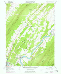
1959 Map of Newton Hamilton
USGS Topo · Published 1977About this map
The Juniata River carves a winding path through the parallel ridges of Mifflin and Huntingdon counties, defining the economic and social geography of the late 1950s. At the river's bend, the borough of Newton Hamilton serves as a hub for local life, flanked by Silver Ford Heights and the Methodist Training Camp. The landscape is dominated by the massive presence of Jacks Mountain and Tuscarora Mountain, which hem in long agricultural and timbered valleys. Throughout these corridors, small communities like Atkinson Mills and Ryde are anchored by rural institutions such as Wayne Ch and the Fairview Sch. The heavy infrastructure of the Penn Central railroad, featuring 4 Tracks along the riverbank, underscores the region's historical role as a primary transportation artery through the Appalachians, linking industrial centers with the agricultural interior of the Tuscarora State Forest.
Find a feature on this map
55 named features on this map. Tap any name to fly to it.
Don’t see what you’re looking for? This feature index may not catch every label — zoom into the map to look around manually.
Map Details
Editions of this 1959 Newton Hamilton Map
3 editions found
Other maps of this area

1919 · Mattawana
USGS Topo · 1:62,500

1919 · Menno
USGS Topo · 1:62,500

1922 · Mt Union
USGS Topo · 1:48,000

1924 · Mt. Union
USGS Topo · 1:62,500

1924 · Lewistown
USGS Topo · 1:62,500

1927 · Lewisburg
USGS Topo · 1:62,500

1935 · Allensville
USGS Topo · 1:62,500

1936 · East Waterford
USGS Topo · 1:48,000

1938 · Allensville
USGS Topo · 1:62,500

1941 · East Waterford
USGS Topo · 1:62,500