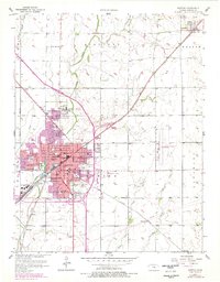
1957 Map of Newton
USGS Topo · Published 1978About this map
Newton serves as a significant rail and educational hub in central Kansas, where the Atchison Topeka and Santa Fe and Missouri Pacific lines converge. The presence of Bethel College in North Newton anchors the northern portion of the urban area, while the city center is densely packed with local institutions including Lincoln Sch, Washington Sch, and Axtell Hospital. The surrounding landscape is defined by the drainage of Sand Creek and Mud Creek, with the rural sections punctuated by one-room schoolhouses like Stone Sch and Shady Side Sch. To the northeast, the smaller settlement of Walton sits along the Santa Fe tracks, maintaining a distinct identity apart from the growing county seat. The purple overprint reveals the physical expansion of the city by the late 1970s, illustrating the shift from a railroad-focused core to modern suburban development.
Find a feature on this map
45 named features on this map. Tap any name to fly to it.
Don’t see what you’re looking for? This feature index may not catch every label — zoom into the map to look around manually.
Map Details
Editions of this 1957 Newton Map
2 editions found
Other maps of this area

1889 · Newton
USGS Topo · 1:125,000

1889 · Wichita
USGS Topo · 1:125,000

1894 · Wichita
USGS Topo · 1:125,000

1894 · Newton
USGS Topo · 1:125,000

1955 · Wichita
USGS Topo · 1:250,000

1955 · Hutchinson
USGS Topo · 1:250,000

1957 · Newton
USGS Topo · 1:24,000

1957 · Peabody NW
USGS Topo · 1:24,000

1957 · Elbing
USGS Topo · 1:24,000

1958 · Wichita
USGS Topo · 1:250,000