1957 Map of Elbing
USGS Topo · Published 1958About this map
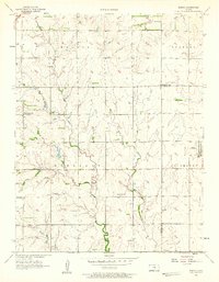
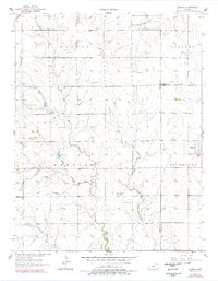
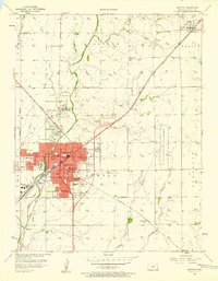
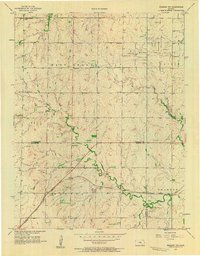
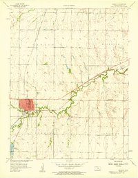
The agrarian landscape of Butler and Harvey Counties in the late 1950s is defined by the convergence of the West Branch Whitewater Creek and East Branch Whitewater Creek. This area, centered on the settlement of Elbing, shows a well-established network of rural section lines and township boundaries including Pleasant, Fairmount, and Walton. The social fabric of this Kansas farming community is revealed through localized institutions, such as the Grace Hill Ch and the Mission Cem. Notable shifts in rural education are visible at the Sugar Grove Sch (Abandoned), which stands in contrast to the still-active Kelly Sch. The inclusion of a central Community Hall suggests a period when these townships remained vital hubs for local governance and social gathering before the further consolidation of rural districts.
Find a feature on this map
15 named features on this map. Tap any name to fly to it.
Don’t see what you’re looking for? This feature index may not catch every label — zoom into the map to look around manually.
Map Details
Editions of this 1957 Elbing Map
2 editions found
Other maps of this area

1889 · Newton
USGS Topo · 1:125,000

1889 · Wichita
USGS Topo · 1:125,000

1894 · Wichita
USGS Topo · 1:125,000

1894 · Newton
USGS Topo · 1:125,000

1955 · Wichita
USGS Topo · 1:250,000

1955 · Hutchinson
USGS Topo · 1:250,000
1957 · Newton
USGS Topo · 1:24,000
1957 · Peabody NW
USGS Topo · 1:24,000
1957 · Peabody
USGS Topo · 1:24,000

1958 · Wichita
USGS Topo · 1:250,000