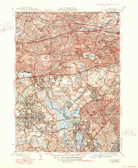
1946 Map of Newton
USGS Topo · Published 1950About this map
The Charles River winds through a dense landscape of mid-century suburban expansion and established institutions in this post-war study of the Boston periphery. Suburban developments like Hancock Village and Oak Hill Park appear alongside academic and social landmarks, including Lasell College, the Newton Theological Institution, and the Perkins Institution for Blind. The map documents a complex infrastructure of transit and public utility, showing the paths of the Boston and Albany RR and the New York New Haven and Hartford RR as they connect the villages of Newton Center, Waban, and Needham. Notable for genealogists are numerous interment sites such as Calvary Cem, Holyhood Cem, and Mt Benedict Cem. Large recreational and natural spaces like the Arnold Arboretum and the Chestnut Hill Reservoir provide a green contrast to the grid of thoroughfares like Commonwealth Ave and the Worcester Turnpike.
Find a feature on this map
124 named features on this map. Tap any name to fly to it.
Don’t see what you’re looking for? This feature index may not catch every label — zoom into the map to look around manually.
Map Details
Editions of this 1946 Newton Map
3 editions found
Other maps of this area

1886 · Dedham
USGS Topo · 1:62,500

1886 · Framingham
USGS Topo · 1:62,500

1887 · Franklin
USGS Topo · 1:62,500

1889 · Franklin
USGS Topo · 1:62,500

1889 · Framingham
USGS Topo · 1:62,500

1893 · Franklin
USGS Topo · 1:62,500

1893 · Boston
USGS Topo · 1:62,500

1894 · Dedham
USGS Topo · 1:62,500

1894 · Framingham
USGS Topo · 1:62,500

1903 · Boston
USGS Topo · 1:62,500