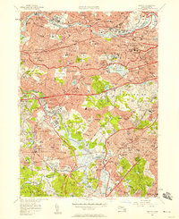
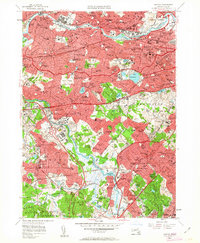
1956 Map of Newton
USGS Topo · Published 1958About this map
The Charles River defines the landscape of the western Boston suburbs in the mid-1950s, winding past the established villages of Waltham, Newton, and Needham. This era of suburban density is marked by a concentration of educational and religious institutions, including Lasell Jr College, Sacred Heart Sch, and St Johns Seminary. The map illustrates the varied character of Newton, from the commercial centers of Newtonville and Auburndale to the residential expansion at Oak Hill Park.
Find a feature on this map
193 named features on this map. Tap any name to fly to it.
Don’t see what you’re looking for? This feature index may not catch every label — zoom into the map to look around manually.
Map Details
Editions of this 1956 Newton Map
3 editions found

Other maps of this area

1886 · Dedham
USGS Topo · 1:62,500

1886 · Framingham
USGS Topo · 1:62,500

1887 · Franklin
USGS Topo · 1:62,500

1889 · Franklin
USGS Topo · 1:62,500

1889 · Framingham
USGS Topo · 1:62,500

1893 · Franklin
USGS Topo · 1:62,500

1893 · Boston
USGS Topo · 1:62,500

1894 · Dedham
USGS Topo · 1:62,500

1894 · Framingham
USGS Topo · 1:62,500

1903 · Boston
USGS Topo · 1:62,500