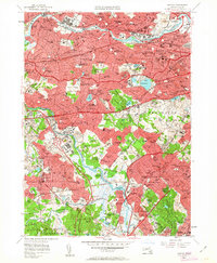
1956 Map of Newton
USGS Topo · Published 1963About this map
The Charles River winds through this mid-century landscape, linking the industrial corridors of Waltham and Watertown with the suburban reaches of Newton and Needham. The map shows a region in transition, where legacy institutions like the Watertown Arsenal and St Johns Seminary stand alongside the emerging postwar highway system, including the Massachusetts Turnpike and Veterans of Foreign Wars Parkway. Educational and religious sites are remarkably dense, featuring prominent landmarks such as Lasell Jr College, Mt Ida Jr College, and the sprawling Mount Auburn Cemetery. Recreational land use is prominent, with numerous golf courses like The Country Club and Brae Burn Country Club preserving large green spaces amidst the densifying residential neighborhoods of Brighton and West Roxbury. The rail network, including the New York New Haven and Hartford RR, remains a vital part of the infrastructure, serving historic hubs like Needham Junction.
Find a feature on this map
172 named features on this map. Tap any name to fly to it.
Don’t see what you’re looking for? This feature index may not catch every label — zoom into the map to look around manually.
Map Details
Editions of this 1956 Newton Map
3 editions found

Other maps of this area

1886 · Dedham
USGS Topo · 1:62,500

1886 · Framingham
USGS Topo · 1:62,500

1887 · Franklin
USGS Topo · 1:62,500

1889 · Franklin
USGS Topo · 1:62,500

1889 · Framingham
USGS Topo · 1:62,500

1893 · Franklin
USGS Topo · 1:62,500

1893 · Boston
USGS Topo · 1:62,500

1894 · Dedham
USGS Topo · 1:62,500

1894 · Framingham
USGS Topo · 1:62,500

1903 · Boston
USGS Topo · 1:62,500