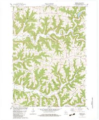
1983 Map of Newton
USGS Topo · Published 1983About this map
Newton sits at a geographic crossroads in Vernon County, where the North Fork Bad Axe River and South Fork Bad Axe River drainage systems define a deeply dissected landscape of ridges and hollows. This early 1980s survey illustrates a rural social fabric organized around family-named terrain and small religious centers like Zion Ch and the Bad Axe Ch. The map detail reveals the distribution of agricultural homesteads and local infrastructure, such as the Hackley Cem and various quarries. Prominent topographic features including Witchcraft Ridge and Lars Anderson Hollow highlight the traditional naming conventions that tie specific families to the land's unique contours. The presence of numerous benchmarks, including BM 1210 near Wayside Park, underscores the precise engineering required to navigate this complex elevation.
Find a feature on this map
60 named features on this map. Tap any name to fly to it.
Don’t see what you’re looking for? This feature index may not catch every label — zoom into the map to look around manually.
Map Details
Editions of this 1983 Newton Map
This is the sole edition of this map. No revisions or reprints were ever made.
Other maps of this area

1903 · Waukon
USGS Topo · 1:125,000

1923 · Viroqua
USGS Topo · 1:62,500

1924 · Gays Mills
USGS Topo · 1:62,500

1926 · Gays Mills
USGS Topo · 1:62,500

1926 · Stoddard
USGS Topo · 1:62,500

1926 · Viroqua
USGS Topo · 1:62,500

1929 · Ferryville
USGS Topo · 1:62,500

1932 · Ferryville
USGS Topo · 1:62,500

1958 · La Crosse
USGS Topo · 1:250,000

1961 · La Crosse
USGS Topo · 1:250,000