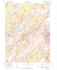
1954 Map of Newton West
USGS Topo · Published 1974About this map
Newton stands as the primary hub of this Sussex County landscape, with its urban street grid and landmark buildings like the Memorial Hospital and St Joseph Cem detailed against the surrounding rural townships. The New York Susquehanna and Western railroad corridor cuts through the valley, serving small stops such as Stillwater Sta and Emmons Sta. This era captures the transition between traditional agriculture and growing institutional land use, evidenced by the presence of Don Bosco College and St Pauls Abbey.
Find a feature on this map
52 named features on this map. Tap any name to fly to it.
Don’t see what you’re looking for? This feature index may not catch every label — zoom into the map to look around manually.
Map Details
Editions of this 1954 Newton West Map
4 editions found
Other maps of this area

1888 · Franklin
USGS Topo · 1:62,500

1888 · Hackettstown
USGS Topo · 1:62,500

1888 · Lake Hopatcong
USGS Topo · 1:62,500

1891 · Wallpack
USGS Topo · 1:62,500

1893 · Wallpack
USGS Topo · 1:62,500

1894 · Hackettstown
USGS Topo · 1:62,500

1894 · Lake Hopatcong
USGS Topo · 1:62,500

1894 · Franklin
USGS Topo · 1:62,500

1897 · Franklin
USGS Topo · 1:62,500

1898 · Lake Hopatcong
USGS Topo · 1:62,500