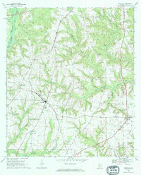
1969 Map of Newville
USGS Topo · Published 1972About this map
Newville serves as the central hub of this 1960s Henry County landscape, where the Seaboard Coast Line railroad cuts a diagonal path through the agricultural terrain. The map documents a community infrastructure rooted in small settlements and rural institutions, notably featuring the Rosenwall Sch and several prominent country churches such as Union Springs Ch and Welcome Ch. The eastern edge of the quadrangle is defined by the flow of the Choctawhatchee River, which is fed by a complex network of tributaries including Abbeville Creek and Sandy Creek. Aviation is represented by both Herrings Airfield and a designated Landing Strip near Tumbleton. From the heights of Rocky Mountain to the waters of Lake Mila, the map illustrates a transition from river-bottom wetlands to the upland farms and homesteads characteristic of the Wiregrass region during this era.
Find a feature on this map
48 named features on this map. Tap any name to fly to it.
Don’t see what you’re looking for? This feature index may not catch every label — zoom into the map to look around manually.
Map Details
Editions of this 1969 Newville Map
2 editions found
Other maps of this area

1953 · Dothan
USGS Topo · 1:250,000

1954 · Dothan
USGS Topo · 1:250,000

1955 · Dothan
USGS Topo · 1:250,000

1969 · Abbeville West
USGS Topo · 1:24,000
1969 · Midland City
USGS Topo · 1:24,000
1969 · Clopton
USGS Topo · 1:24,000

1969 · Headland
USGS Topo · 1:24,000

1969 · Abbeville East
USGS Topo · 1:24,000
1969 · Echo
USGS Topo · 1:24,000

1969 · Newville
USGS Topo · 1:24,000