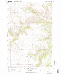
1967 Map of Nezperce SE
USGS Topo · Published 1970About this map
Nez Perce Indian Reservation Boundary cuts across the southern portion of this landscape, marking a significant jurisdictional and cultural line in Idaho County. The terrain is defined by the deep drainage of Cottonwood Creek, which dominates the central and northern sections of the sheet. Settlers and local families established landmarks on the higher ground, notably at Mt Zion where the Mt Zion Cem is located, providing a focal point for genealogical research in this rural area. Smaller waterways like Red Rock Creek and Threemile Creek feed the larger drainage system, while several Gravel Pits and a Borrow Pit indicate localized earth-moving activity. A network of Jeep Trails provides the primary access through the steeper sections of the creek breaks, illustrating the remote and specialized transportation patterns of the late 1960s.
Find a feature on this map
9 named features on this map. Tap any name to fly to it.
Don’t see what you’re looking for? This feature index may not catch every label — zoom into the map to look around manually.
Map Details
Editions of this 1967 Nezperce SE Map
2 editions found
Other maps of this area

1924 · Kamiah
USGS Topo · 1:125,000

1924 · Weippe
USGS Topo · 1:125,000

1931 · Buffalo Hump
USGS Topo · 1:125,000

1934 · Buffalo Hump
USGS Topo · 1:125,000

1955 · Pullman
USGS Topo · 1:250,000

1955 · Grangeville
USGS Topo · 1:250,000

1956 · Elk City
USGS Topo · 1:250,000

1956 · Hamilton
USGS Topo · 1:250,000

1958 · Pullman
USGS Topo · 1:250,000

1959 · Grangeville
USGS Topo · 1:250,000