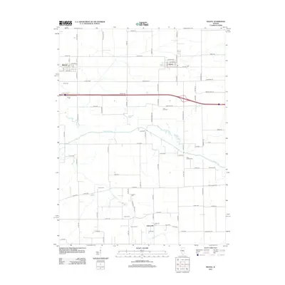
2012 Map of Niantic
USGS Topo · Published 2012About this map
The Sangamon River meanders across this central Illinois landscape, defining the rural character of the borderlands between Sangamon and Macon counties. The agricultural grid is punctuated by the established settlements of Illiopolis and Niantic, which anchor the northern half of the sheet along the historic corridor of Old Route 36. This area is particularly dense with small family and community burial grounds, reflecting generations of local settlement. Genealogists and local historians can trace locations like Wilcox Cem, Stafford Cem, and Hunter Cem, alongside the Berea Christian Cem further east. Water features such as Calamus Lake, Otter Lake, and the winding Mosquito Cr illustrate the drainage patterns of the prairie, while small named locales like Osbernville and Simmons Farm highlight the enduring importance of family-named landholdings in this farming region.
Find a feature on this map
90 named features on this map. Tap any name to fly to it.
Don’t see what you’re looking for? This feature index may not catch every label — zoom into the map to look around manually.
Map Details
Editions of this 2012 Niantic Map
This is the sole edition of this map. No revisions or reprints were ever made.
Other maps of this area

1923 · Taylorville
USGS Topo · 1:62,500

1925 · Taylorville
USGS Topo · 1:62,500

1952 · Assumption
USGS Topo · 1:62,500

1954 · Niantic
USGS Topo · 1:62,500

1954 · Mechanicsburg
USGS Topo · 1:62,500

1958 · Decatur
USGS Topo · 1:250,000

1961 · Decatur
USGS Topo · 1:250,000

1982 · Harristown
USGS Topo · 1:24,000
1982 · Stonington
USGS Topo · 1:24,000
1982 · Lake Fork
USGS Topo · 1:24,000