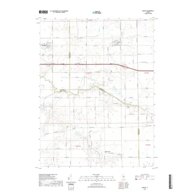
2018 Map of Niantic
USGS Topo · Published 2018About this map
Illiopolis and Niantic anchor the northern portion of this Central Illinois landscape, where the grain-growing plains are dissected by the winding course of the Sangamon River. The river corridor creates a complex network of wetlands and oxbows, including Goose Neck Slough, Long Point Slough, and Old River, which contrast sharply with the rigid grid of the surrounding agricultural township sections. This area marks a significant convergence of three counties—Sangamon, Macon, and Christian—each meeting amidst the fertile bottomlands.
Find a feature on this map
100 named features on this map. Tap any name to fly to it.
Don’t see what you’re looking for? This feature index may not catch every label — zoom into the map to look around manually.
Map Details
Editions of this 2018 Niantic Map
This is the sole edition of this map. No revisions or reprints were ever made.
Other maps of this area

1923 · Taylorville
USGS Topo · 1:62,500

1925 · Taylorville
USGS Topo · 1:62,500

1952 · Assumption
USGS Topo · 1:62,500

1954 · Niantic
USGS Topo · 1:62,500

1954 · Mechanicsburg
USGS Topo · 1:62,500

1958 · Decatur
USGS Topo · 1:250,000

1961 · Decatur
USGS Topo · 1:250,000

1982 · Harristown
USGS Topo · 1:24,000
1982 · Stonington
USGS Topo · 1:24,000
1982 · Lake Fork
USGS Topo · 1:24,000