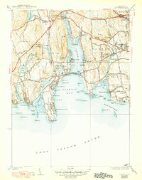
1938 Map of Niantic
USGS Topo · Published 1950About this map
The Niantic River and its expansive bay define this coastal landscape on the eve of the 1940s, separating the townships of East Lyme and Waterford. This era shows a transition from traditional maritime and granite-quarrying industries toward a recreation-focused shoreline. Along the western coast, Rocky Neck State Park and Attawan Beach signal the growing importance of the summer season, while the New York New Haven and Hartford railroad tracks parallel the coast, connecting the village of Niantic to regional trade. Inland, the presence of the Farm For Women and the State Sanatorium reflect the state's institutional land use of the period. To the north, the cluster at Golden Spur and the Stone Church mark older centers of community life, even as the Boston Post Road begins to carry increasing motor traffic through the hills.
Find a feature on this map
121 named features on this map. Tap any name to fly to it.
Don’t see what you’re looking for? This feature index may not catch every label — zoom into the map to look around manually.
Map Details
Editions of this 1938 Niantic Map
3 editions found

Other maps of this area

1892 · New London
USGS Topo · 1:62,500

1893 · New London
USGS Topo · 1:62,500

1893 · Saybrook
USGS Topo · 1:62,500

1903 · Gardiners Island
USGS Topo · 1:62,500

1904 · Gardiners Island
USGS Topo · 1:62,500

1921 · Gardiners Island
USGS Topo · 1:62,500

1921 · New London
USGS Topo · 1:62,500

1934 · Niantic
USGS Topo · 1:24,000

1935 · Montville
USGS Topo · 1:24,000

1938 · New London
USGS Topo · 1:31,680