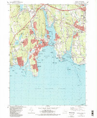
1983 Map of Niantic
USGS Topo · Published 1988About this map
Niantic Bay and the coastal waters of Long Island Sound define this 1980s landscape of maritime infrastructure and residential growth. The eastern shore of the Niantic River is dominated by a mix of specialized facilities, including the Millstone Nuclear Power Plant and the Naval Underwater Systems Center near Millstone Point. Further inland, the map captures the community of Niantic and the coastal developments at Crescent Beach and Attawan Beach, illustrating the transition from seasonal shorefronts to established neighborhoods.
Find a feature on this map
132 named features on this map. Tap any name to fly to it.
Don’t see what you’re looking for? This feature index may not catch every label — zoom into the map to look around manually.
Map Details
Editions of this 1983 Niantic Map
3 editions found
Other maps of this area

1892 · New London
USGS Topo · 1:62,500

1893 · New London
USGS Topo · 1:62,500

1893 · Saybrook
USGS Topo · 1:62,500

1903 · Gardiners Island
USGS Topo · 1:62,500

1904 · Gardiners Island
USGS Topo · 1:62,500

1921 · Gardiners Island
USGS Topo · 1:62,500

1921 · New London
USGS Topo · 1:62,500

1934 · Niantic
USGS Topo · 1:24,000

1935 · Montville
USGS Topo · 1:24,000

1938 · New London
USGS Topo · 1:31,680