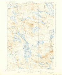
1934 Map of Nicatous Lake
USGS Topo · Published 1941About this map
Nicatous Lake dominates this inland Maine wilderness, serving as the central hub for a complex network of waterways including West Lake, Duck Lake, and Spring Lake. The early 20th-century character of the region is defined by its recreation and forestry outposts, noted here by the Nicatous Club, Poplar Tavern Camp, and the Explorers Club near Lower Syladobsis Lake. The landscape is a mosaic of glacial features, from the expansive 1000 Acre Heath in the northwest to the prominent heights of Duck Mtn and Sabao Mountain. Surveyed in the 1930s using aerial photography from the U.S. Army Air Corps, the map captures the transition of the Maine woods into a managed recreational landscape. Loggers and sportsmen likely frequented the numbered camps, such as No 6 Camp and No 2 Camp, while the Passadumkeag River provided a critical drainage route through the township system of Lakeville and surrounding unorganized territories.
Find a feature on this map
108 named features on this map. Tap any name to fly to it.
Don’t see what you’re looking for? This feature index may not catch every label — zoom into the map to look around manually.
Map Details
Editions of this 1934 Nicatous Lake Map
4 editions found
Other maps of this area

1920 · Winn
USGS Topo · 1:62,500

1929 · Great Pond
USGS Topo · 1:48,000

1929 · Lead Mountain
USGS Topo · 1:48,000

1931 · Springfield
USGS Topo · 1:48,000

1931 · Saponac
USGS Topo · 1:48,000

1932 · Nicatous Lake
USGS Topo · 1:48,000

1932 · Lead Mountain
USGS Topo · 1:62,500

1932 · Great Pond
USGS Topo · 1:62,500

1934 · Saponac
USGS Topo · 1:62,500

1934 · Nicatous Lake
USGS Topo · 1:62,500