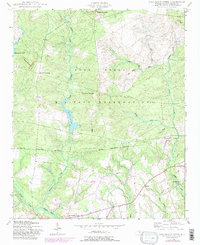
1948 Map of Nicholson Creek
USGS Topo · Published 1983About this map
Fort Bragg Military Reservation dominates the northern half of this landscape, where the sandhills of Hoke County transition into a dense network of riparian corridors. The geography is defined by the namesake Nicholson Creek and the expansive Mott Lake, which serve as central anchors for the military lands. Just beyond the Military Reservation Boundary, the landscape shifts toward a rural agricultural pattern typical of the mid-20th century, centered around small community hubs like Campbells Crossroads and Wayside.
Find a feature on this map
28 named features on this map. Tap any name to fly to it.
Don’t see what you’re looking for? This feature index may not catch every label — zoom into the map to look around manually.
Map Details
Editions of this 1948 Nicholson Creek Map
4 editions found
Other maps of this area

1948 · Southern Pines
USGS Topo · 1:62,500

1948 · Clifdale
USGS Topo · 1:62,500

1948 · Nicholson Creek
USGS Topo · 1:24,000

1948 · Clifdale
USGS Topo · 1:24,000

1948 · Mc Cain
USGS Topo · 1:24,000

1949 · Wagram
USGS Topo · 1:24,000

1949 · Laurinburg
USGS Topo · 1:62,500

1950 · Clifdale
USGS Topo · 1:24,000

1950 · Sanatorium
USGS Topo · 1:24,000

1950 · Lobelia
USGS Topo · 1:24,000