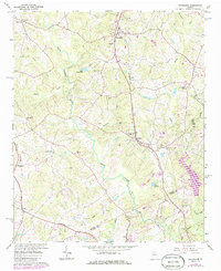
1964 Map of Nicholson
USGS Topo · Published 1986About this map
The North Oconee River winds through the heart of this North Georgia landscape, defining the topography between Jackson, Clarke, and Madison counties. During the mid-1960s, the rural character of the region remained centered around small community hubs like Nicholson and Center, where the Southern railway provided a primary north-south transportation corridor. Local life is anchored by numerous country churches such as Antioch Ch, Bethany Ch, and Shiloh Ch, alongside the Benton Sch. Cultural and ancestral sites are scattered across the terrain, from the Stapler Cem and Stone Cem to small settlements like Brockton and Attica. Several impoundments, including Lake Yamacutah and Lake Jarekit, dot the drainages of Sandy Creek and Little Curry Creek, reflecting the importance of water management for local agriculture and community use in this era.
Find a feature on this map
43 named features on this map. Tap any name to fly to it.
Don’t see what you’re looking for? This feature index may not catch every label — zoom into the map to look around manually.
Map Details
Editions of this 1964 Nicholson Map
2 editions found
Other maps of this area

1891 · Gainesville
USGS Topo · 1:125,000

1891 · Carnesville
USGS Topo · 1:125,000

1896 · Monroe
USGS Topo · 1:125,000

1953 · Athens
USGS Topo · 1:250,000

1954 · Greenville
USGS Topo · 1:250,000

1958 · Greenville
USGS Topo · 1:250,000

1958 · Athens
USGS Topo · 1:250,000

1959 · Athens
USGS Topo · 1:250,000

1963 · Athens
USGS Topo · 1:250,000

1964 · Commerce
USGS Topo · 1:24,000