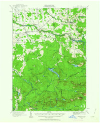
1919 Map of Nicholville
USGS Topo · Published 1963About this map
The St Regis River and its multiple branches carve through this northern New York landscape, anchoring established riverside settlements like Nicholville, St Regis Falls, and Fort Jackson. Surveyed shortly after the Great War, the map reveals a rural society structured around local education, with numerous numbered schoolhouses such as School No. 5 and School No. 7 serving the townships of Lawrence and Hopkinton.
Find a feature on this map
86 named features on this map. Tap any name to fly to it.
Don’t see what you’re looking for? This feature index may not catch every label — zoom into the map to look around manually.
Map Details
Editions of this 1919 Nicholville Map
2 editions found
Other maps of this area

1905 · Saint Regis
USGS Topo · 1:62,500

1906 · Massena
USGS Topo · 1:62,500

1907 · Massena
USGS Topo · 1:62,500

1908 · Potsdam
USGS Topo · 1:62,500

1915 · Malone
USGS Topo · 1:62,500

1915 · Moira
USGS Topo · 1:62,500

1917 · Malone
USGS Topo · 1:62,500

1917 · Moira
USGS Topo · 1:62,500

1919 · Nicholville
USGS Topo · 1:62,500

1920 · Childwold
USGS Topo · 1:62,500