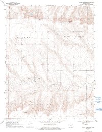
1969 Map of Nickel Mine Spring
USGS Topo · Published 1993About this map
Nickel Mine Spring marks a vital water source in this high plains landscape of Logan County, where the topography is defined by the sharp drainage of Twin Butte Creek. The map reveals a transition from the elevated plateaus of the Western and Russell Springs townships toward the more dissected breaks of the Augustine and Paxton districts. While the area is largely characterized by its natural contours, small-scale industrial activity is evident in the presence of a Gravel Pit and a Quarry, suggesting the local extraction of materials for road construction or ranching needs during the late 1960s. The dense concentration of contour lines illustrates the significant relief between the upland flats and the creek beds that cut through this section of the Kansas prairie.
Find a feature on this map
11 named features on this map. Tap any name to fly to it.
Don’t see what you’re looking for? This feature index may not catch every label — zoom into the map to look around manually.
Map Details
Editions of this 1969 Nickel Mine Spring Map
2 editions found
Other maps of this area

1939 · Pence
USGS Topo · 1:62,500

1941 · Pence
USGS Topo · 1:62,500

1955 · Scott City
USGS Topo · 1:250,000

1958 · Scott City
USGS Topo · 1:250,000

1968 · Russell Springs 3 NW
USGS Topo · 1:24,000

1968 · Russell Springs 3 NE
USGS Topo · 1:24,000

1969 · Russell Springs 2 NW
USGS Topo · 1:24,000

1969 · Russell Springs 2 SW
USGS Topo · 1:24,000

1969 · Russell Springs 2 NE
USGS Topo · 1:24,000

1969 · Russell Springs 2 SE
USGS Topo · 1:24,000