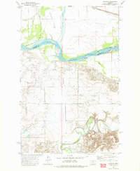
1972 Map of Nickwall
USGS Topo · Published 1975About this map
The Missouri River and its confluence area with the Redwater River dominate this 1972 survey of the borderlands between McCone and Roosevelt Counties. This stretch of the river is defined by complex water features like Chelsea Slough and the expansive Chelsea Island, illustrating the shifting hydrology of the Missouri before modern stabilization. On the southern bluffs, the small settlement of Nickwall sits at a junction of the Nickwall Road, serving as a local hub near the Pleasant View Cem.
Find a feature on this map
17 named features on this map. Tap any name to fly to it.
Don’t see what you’re looking for? This feature index may not catch every label — zoom into the map to look around manually.
Map Details
Editions of this 1972 Nickwall Map
This is the sole edition of this map. No revisions or reprints were ever made.
Other maps of this area

1912 · Chelsea
USGS Topo · 1:62,500

1912 · Poplar
USGS Topo · 1:62,500

1954 · Glendive
USGS Topo · 1:250,000

1954 · Wolf Point
USGS Topo · 1:250,000

1957 · Glendive
USGS Topo · 1:250,000

1958 · Wolf Point
USGS Topo · 1:250,000

1958 · Glendive
USGS Topo · 1:250,000

1972 · Chelsea SW
USGS Topo · 1:24,000

1972 · Poplar
USGS Topo · 1:24,000

1972 · Chelsea
USGS Topo · 1:24,000