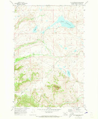
1970 Map of Nilan Reservoir
USGS Topo · Published 1973About this map
The waters of Nilan Reservoir and Smith Lake dominate this high-plains landscape, where the prairie meets the rising foothills of Lewis and Clark County. This 1970s record shows a region defined by ranching and water management, centered on the L F Ranch and a network of named waterways including Willow Creek and Smith Creek. The terrain transitions sharply from the reservoir flats to the prominent elevation of Haystack Butte, while Swallow Canyon carves through the eastern portion of the sheet. For the researcher, the map preserves the exact locations of several seasonal Springs and multiple Gravel Pit sites, reflecting the local infrastructure requirements of the era. The presence of a Jeep Trail and a designated Picnic Area at the reservoir suggests the dual nature of the land as both working range and a destination for outdoor recreation during the early 1970s.
Find a feature on this map
19 named features on this map. Tap any name to fly to it.
Don’t see what you’re looking for? This feature index may not catch every label — zoom into the map to look around manually.
Map Details
Editions of this 1970 Nilan Reservoir Map
This is the sole edition of this map. No revisions or reprints were ever made.
Other maps of this area

1903 · Saypo
USGS Topo · 1:125,000

1903 · Coopers Lake
USGS Topo · 1:125,000

1920 · Choteau
USGS Topo · 1:125,000

1943 · Hogan
USGS Topo · 1:125,000

1955 · Choteau
USGS Topo · 1:250,000

1957 · Choteau
USGS Topo · 1:250,000

1958 · Choteau
USGS Topo · 1:250,000

1958 · Barr Creek
USGS Topo · 1:24,000

1958 · Sawtooth Ridge
USGS Topo · 1:24,000

1960 · Gilman
USGS Topo · 1:62,500