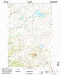
1995 Map of Nilan Reservoir
USGS Topo · Published 1997About this map
Nilan Reservoir dominates the northeastern landscape of this mid-1990s survey, representing a significant water management feature in this part of Lewis and Clark County. The surrounding terrain transitions from the high, distinctive summit of Haystack Butte in the south to a network of drainage systems including Ford Creek, Smith Creek, and the curiously named Blubber Creek. Ranching history is anchored by the L F Ranch, situated near the confluence of several seasonal streams.
Find a feature on this map
17 named features on this map. Tap any name to fly to it.
Don’t see what you’re looking for? This feature index may not catch every label — zoom into the map to look around manually.
Map Details
Editions of this 1995 Nilan Reservoir Map
This is the sole edition of this map. No revisions or reprints were ever made.
Other maps of this area

1903 · Saypo
USGS Topo · 1:125,000

1903 · Coopers Lake
USGS Topo · 1:125,000

1920 · Choteau
USGS Topo · 1:125,000

1943 · Hogan
USGS Topo · 1:125,000

1955 · Choteau
USGS Topo · 1:250,000

1957 · Choteau
USGS Topo · 1:250,000

1958 · Choteau
USGS Topo · 1:250,000

1958 · Barr Creek
USGS Topo · 1:24,000

1958 · Sawtooth Ridge
USGS Topo · 1:24,000

1960 · Gilman
USGS Topo · 1:62,500