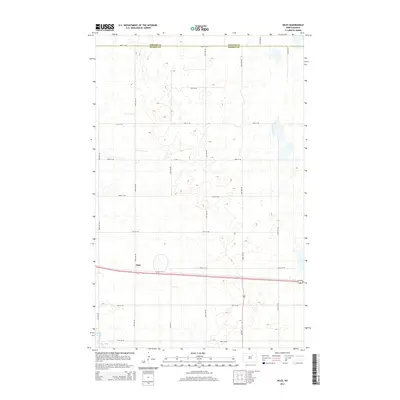
2014 Map of Niles
USGS Topo · Published 2014About this map
The settlement of Niles sits at a critical junction of northern North Dakota's prairie landscape, positioned along the east-west corridor of Us-2. This 2014 survey documents the agricultural grid typical of the region, where the boundary between Towner Co and Benson Co bisects the northern section of the map. The terrain is defined by a high density of small wetlands and depressions, characteristic of the prairie pothole region, culminating in the northern reaches of Lake Ibsen near the southwestern corner. Transportation remains the dominant human imprint on the land, with the intersection of Us-281 and Us-2 providing the primary transit nodes for local residents and long-distance travelers alike. The map captures a moment of modern rural infrastructure, from the numbering of secondary routes like CR-0325 to the precise section-line roads such as 60th St NE.
Find a feature on this map
23 named features on this map. Tap any name to fly to it.
Don’t see what you’re looking for? This feature index may not catch every label — zoom into the map to look around manually.
Map Details
Editions of this 2014 Niles Map
This is the sole edition of this map. No revisions or reprints were ever made.
Other maps of this area

1932 · Grahams Island
USGS Topo · 1:62,500

1950 · Grahams Island
USGS Topo · 1:62,500

1951 · Tilden
USGS Topo · 1:24,000

1953 · Devils Lake
USGS Topo · 1:250,000

1956 · Devils Lake
USGS Topo · 1:250,000

1956 · Brinsmade
USGS Topo · 1:24,000

1957 · Comstock
USGS Topo · 1:24,000

1957 · Cando
USGS Topo · 1:24,000

1957 · Churchs Ferry
USGS Topo · 1:24,000
1957 · Brinsmade
USGS Topo · 1:24,000