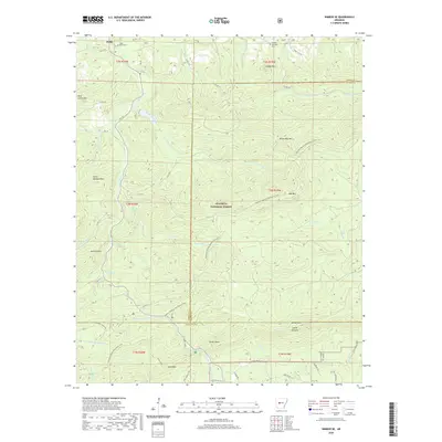
2020 Map of Nimrod SE
USGS Topo · Published 2020About this map
Hollis sits along State Hwy 7 in this corner of the Ouachita National Forest, where the terrain is defined by a dense network of mountain ridges and river forks. The landscape transitions between the watersheds of the Middle Fork Saline River and the N Fork Ouachita River, with numerous creeks such as Sugar Cr and Trace Cr cutting through the highlands. Local history is anchored by the Bluff Cem and Forked Mountain Cem, both located in the northern reaches of the quadrangle. The area is a significant hub for recreation, as the Ouachita National Recreation Trail winds across the peaks, passing near Oak Mtn and Smith Pinnacle. These elevations, including Forked Mtn and Short Mtn, provide a clear picture of the complex topography that constrained early settlement to the narrow creek valleys.
Find a feature on this map
57 named features on this map. Tap any name to fly to it.
Don’t see what you’re looking for? This feature index may not catch every label — zoom into the map to look around manually.
Map Details
Editions of this 2020 Nimrod SE Map
This is the sole edition of this map. No revisions or reprints were ever made.
Other maps of this area

1890 · Benton
USGS Topo · 1:125,000

1890 · Hot Springs
USGS Topo · 1:125,000

1894 · Hot Springs
USGS Topo · 1:125,000

1894 · Benton
USGS Topo · 1:125,000

1955 · Little Rock
USGS Topo · 1:250,000

1956 · Little Rock
USGS Topo · 1:250,000

1960 · Little Rock
USGS Topo · 1:250,000

1963 · Paron SW
USGS Topo · 1:24,000
1963 · Aplin
USGS Topo · 1:24,000

1964 · Little Rock
USGS Topo · 1:250,000