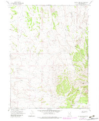
1967 Map of Ninemile Mtn SW
USGS Topo · Published 1983About this map
Peach Ranch lies at the southern edge of this high-desert landscape in Elko County, marking a rare point of human habitation in a region defined by its water scarcity and livestock management. Surveyed in the late 1960s with updates into the early 1980s, the map illustrates the critical infrastructure of the Great Basin cattle industry. The terrain is a network of strategic water sources, ranging from natural flows like North Spring and Lewis Spring to man-made improvements including Eightyfoot Well, Jog Well, and the colorfully named Toilet Well No 1.
Find a feature on this map
14 named features on this map. Tap any name to fly to it.
Don’t see what you’re looking for? This feature index may not catch every label — zoom into the map to look around manually.
Map Details
Editions of this 1967 Ninemile Mtn SW Map
3 editions found
Other maps of this area

1955 · Wells
USGS Topo · 1:250,000

1958 · Wells
USGS Topo · 1:250,000

1961 · Wells
USGS Topo · 1:250,000

1967 · Valley Pass
USGS Topo · 1:24,000

1967 · Loray
USGS Topo · 1:24,000

1967 · Montello Canyon
USGS Topo · 1:24,000

1967 · Ninemile Mtn NE
USGS Topo · 1:24,000

1967 · Ninemile Mtn SW
USGS Topo · 1:24,000

1967 · Ninemile Mtn
USGS Topo · 1:24,000

1968 · Pequop
USGS Topo · 1:24,000