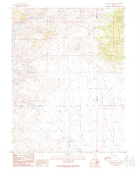
1989 Map of Ninemile Peak
USGS Topo · Published 1989About this map
The East Walker River flows through the northwestern corner of this high-desert landscape, defining a narrow corridor of activity in a region shaped by ranching and mineral exploration. In the late 20th century, the Ninemile Ranch stands as the primary namesake settlement near the southern boundary, where Bodie Creek and Rough Creek converge. The terrain is marked by various extractive efforts, from the Gravel Pit operations near the county line to scattered prospects and specialized open pit mines. Spanning the border of Lyon and Mineral Counties, the map illustrates a sparsely populated territory where water sources and geologic potential dictate the placement of human improvements in an otherwise arid expanse.
Find a feature on this map
9 named features on this map. Tap any name to fly to it.
Don’t see what you’re looking for? This feature index may not catch every label — zoom into the map to look around manually.
Map Details
Editions of this 1989 Ninemile Peak Map
This is the sole edition of this map. No revisions or reprints were ever made.
Other maps of this area

1926 · Roberts Mountains
USGS Topo · 1:250,000

1929 · Roberts Mountains
USGS Topo · 1:250,000

1955 · Millett
USGS Topo · 1:250,000

1956 · Bellevue Peak
USGS Topo · 1:62,500

1956 · Cockalorum Wash
USGS Topo · 1:62,500

1956 · Horse Heaven Mtn
USGS Topo · 1:62,500

1956 · Antelope Peak
USGS Topo · 1:62,500

1959 · Millett
USGS Topo · 1:250,000

1978 · Summit Mountain
USGS Topo · 1:100,000
1990 · Ninemile Peak
USGS Topo · 1:24,000