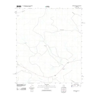
2010 Map of Ninemile Ranch
USGS Topo · Published 2010About this map
Ninemile Ranch and the small settlement of Emerson anchor this landscape in Terrell County, characterized by a complex network of seasonal watercourses and ranch infrastructure. The hydrology of the region is defined by prominent drainages such as Sanderson Creek, Fortyone Draw, and Red Windmill Draw, which carve through the terrain alongside named features like Whitely Canyon. Water management is essential in this arid environment, as evidenced by the mapping of Fortyone Tank and Jackson Tank. Transportation is limited to a sparse grid of rural routes, including Nine Mile Rd and Six Mile Rd, which connect these remote outposts. The map provides a clear view of the territorial organization of West Texas ranching, where large landholdings are identified by their primary draws and essential watering holes rather than dense urban development.
Find a feature on this map
13 named features on this map. Tap any name to fly to it.
Don’t see what you’re looking for? This feature index may not catch every label — zoom into the map to look around manually.
Map Details
Editions of this 2010 Ninemile Ranch Map
This is the sole edition of this map. No revisions or reprints were ever made.
Other maps of this area

1920 · Longfellow
USGS Topo · 1:125,000

1928 · Sanderson
USGS Topo · 1:125,000

1954 · Fort Stockton
USGS Topo · 1:250,000

1958 · Fort Stockton
USGS Topo · 1:250,000

1968 · Big Brindle Canyon
USGS Topo · 1:24,000

1968 · Toms Canyon
USGS Topo · 1:24,000

1968 · F C Ranch
USGS Topo · 1:24,000

1968 · Fresno Creek
USGS Topo · 1:24,000

1968 · Longfellow
USGS Topo · 1:24,000

1968 · Ninemile Ranch
USGS Topo · 1:24,000