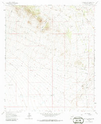
1962 Map of Ninetysix Ranch
USGS Topo · Published 1986About this map
Langford Mountains rise sharply in the northwest corner of this New Mexico survey, overlooking an arid landscape defined by its vital water-sourcing infrastructure. The map documents a ranching economy dependent on subterranean water, evidenced by a network of named landmarks such as Glaze Windmill, Lucky Windmill, and Pendleton Windmill. The namesake Ninetysix Ranch is situated along the banks of Ninetysix Creek, while the historic Butterfield Trail cuts across the center of the sheet, marking a legacy of western passage. Transportation and resource management are further detailed through the Separ Road and a prominent industrial pipeline that traverses the terrain. This record provides a clear view of the territorial organization of Grant County, from the seasonal drainage of Smith Draw to cattle-related features like the Corral and Glaze Tank.
Find a feature on this map
25 named features on this map. Tap any name to fly to it.
Don’t see what you’re looking for? This feature index may not catch every label — zoom into the map to look around manually.
Map Details
Editions of this 1962 Ninetysix Ranch Map
2 editions found
Other maps of this area

1954 · Silver City
USGS Topo · 1:250,000

1958 · Silver City
USGS Topo · 1:250,000

1962 · Silver City
USGS Topo · 1:250,000

1962 · Ninetysix Ranch
USGS Topo · 1:24,000

1962 · Lisbon
USGS Topo · 1:24,000

1963 · Gold Hill
USGS Topo · 1:24,000

1963 · Soldiers Farewell Hill
USGS Topo · 1:24,000
1963 · Werney Hill
USGS Topo · 1:24,000
1963 · C Bar Ranch
USGS Topo · 1:24,000

1964 · Muir Ranch
USGS Topo · 1:24,000