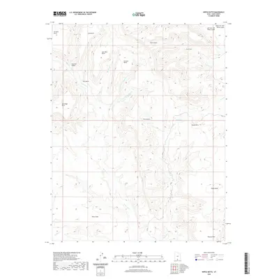
2020 Map of Nipple Butte
USGS Topo · Published 2020About this map
Nipple Butte stands as a prominent landmark in this section of Kane County, where the high desert landscape is defined by a series of expansive plateaus known locally as benches. These elevated features, such as John Wills Bench, Ty Hatch Bench, and Sit Down Bench, carry the names of early figures and reflect the long history of livestock grazing and land use in this part of Utah. The intricate drainage network includes Wahweap Cr and the seasonally active Coyote Cr, which carve through the sandstone to form complex geological features like Clints Canyon and the pocket-like Clints Coves.
Find a feature on this map
27 named features on this map. Tap any name to fly to it.
Don’t see what you’re looking for? This feature index may not catch every label — zoom into the map to look around manually.
Map Details
Editions of this 2020 Nipple Butte Map
This is the sole edition of this map. No revisions or reprints were ever made.
Other maps of this area

1886 · Escalante
USGS Topo · 1:250,000

1922 · Upper Last Chance
USGS Topo · 1:63,360

1953 · Nipple Butte
USGS Topo · 1:62,500

1954 · Paria
USGS Topo · 1:62,500

1956 · Escalante
USGS Topo · 1:250,000

1960 · Escalante
USGS Topo · 1:250,000

1964 · Horse Flat
USGS Topo · 1:24,000

1968 · Fourmile Bench
USGS Topo · 1:24,000
1968 · Ship Mountain Point
USGS Topo · 1:24,000
1981 · Tibbet Bench
USGS Topo · 1:24,000