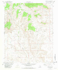
1981 Map of Nipple Butte
USGS Topo · Published 1981About this map
Nipple Butte rises as a prominent landmark over a landscape defined by expansive mesas and drainages in this 1981 survey. The terrain is segmented into several named flat-topped formations, including John Wills Bench, Snow Bench, and Jack Riggs Bench, which overlook the winding course of Wahweap Creek. To the south, the topographical character shifts toward the shifting dunes of White Sands and the distinctive promontory at Haycock Point.
Find a feature on this map
21 named features on this map. Tap any name to fly to it.
Don’t see what you’re looking for? This feature index may not catch every label — zoom into the map to look around manually.
Map Details
Editions of this 1981 Nipple Butte Map
This is the sole edition of this map. No revisions or reprints were ever made.
Other maps of this area

1886 · Escalante
USGS Topo · 1:250,000

1922 · Upper Last Chance
USGS Topo · 1:63,360

1953 · Nipple Butte
USGS Topo · 1:62,500

1954 · Paria
USGS Topo · 1:62,500

1956 · Escalante
USGS Topo · 1:250,000

1960 · Escalante
USGS Topo · 1:250,000

1964 · Horse Flat
USGS Topo · 1:24,000

1968 · Fourmile Bench
USGS Topo · 1:24,000
1968 · Ship Mountain Point
USGS Topo · 1:24,000
1981 · Tibbet Bench
USGS Topo · 1:24,000