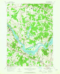
1954 Map of Niskayuna
USGS Topo · Published 1965About this map
The Mohawk River serves as the central artery of this mid-century landscape, dividing Saratoga County to the north from Schenectady and Albany Counties to the south. Historically significant river crossings are well-documented, including Vischer Ferry and Dunsbach Ferry, alongside the infrastructure of the Erie Canal (Abandoned) and Lock No 7. The southern portion of the sheet reveals the early expansion of Latham and Niskayuna, with the Albany Municipal Airport and the New York Central Railroad shaping the regional transportation network.
Find a feature on this map
71 named features on this map. Tap any name to fly to it.
Don’t see what you’re looking for? This feature index may not catch every label — zoom into the map to look around manually.
Map Details
Editions of this 1954 Niskayuna Map
4 editions found
Other maps of this area

1893 · Cohoes
USGS Topo · 1:62,500

1893 · Troy
USGS Topo · 1:62,500

1893 · Schenectady
USGS Topo · 1:62,500

1893 · Albany
USGS Topo · 1:62,500

1895 · Troy
USGS Topo · 1:62,500

1895 · Cohoes
USGS Topo · 1:62,500

1895 · Albany
USGS Topo · 1:62,500

1895 · Schenectady
USGS Topo · 1:62,500

1898 · Schenectady
USGS Topo · 1:62,500

1898 · Albany
USGS Topo · 1:62,500