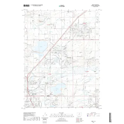
2019 Map of Niwot
USGS Topo · Published 2019About this map
Niwot and Gunbarrel anchor this detailed landscape north of Boulder, where the Front Range plains meet an intricate network of irrigation and water management. The area is defined by its agricultural and industrial legacy, tracing the Holland Ditch, Hinman Ditch, and Boulder and Left Hand Ditch as they move water across the basin toward Dodd Reservoir and Boulder Reservoir. Prominent landmarks like Valmont Butte and Haystack Mtn provide vertical relief in an otherwise developing corridor that includes the Boulder Municipal Airport and Ashlawn Airport. Local history is preserved in sites such as Niwot Cemetery and Valmont Cemetery, while the growing footprint of Lafayette appears in the southeast. This survey illustrates how suburban expansion has integrated with existing infrastructure, from the railroad tracks near Valmont to the expansive LoBo Trail system connecting these historic communities.
Find a feature on this map
90 named features on this map. Tap any name to fly to it.
Don’t see what you’re looking for? This feature index may not catch every label — zoom into the map to look around manually.
Map Details
Editions of this 2019 Niwot Map
This is the sole edition of this map. No revisions or reprints were ever made.
Other maps of this area

1899 · West Denver
USGS Topo · 1:125,000

1902 · Boulder
USGS Topo · 1:62,500

1904 · Niwot
USGS Topo · 1:62,500

1904 · Boulder
USGS Topo · 1:62,500

1906 · Blackhawk
USGS Topo · 1:62,500

1940 · Lafayette
USGS Topo · 1:31,680

1942 · Eldorado Springs
USGS Topo · 1:24,000

1942 · Louisville
USGS Topo · 1:31,680

1944 · Lafayette
USGS Topo · 1:31,680

1944 · Eldorado Springs
USGS Topo · 1:31,680