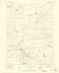
1951 Map of Niwot
USGS Topo · Published 1951About this map
Left-hand Creek and Boulder Creek carve through this agricultural landscape, defined by an intricate network of irrigation including the Hinman Ditch and Farmers Ditch. The 1951 landscape is anchored by the settlement of Niwot and the industrial activity near Valmont, where a Fluorspar Mill, Brickyard, and Power Plant operate near the prominent Valmont Butte. Transportation is dominated by the Burlington Route and Union Pacific railroads, which facilitated the movement of goods and people between the region's scattered farmsteads and schools. The presence of Boulder Airport and numerous small schoolhouses like Batchelder School and White Rock School highlights a community transitioning from isolated rural life toward mid-century modernization. For genealogists, the map preserves the locations of the Niwot Cemetery and Montview Cemetery, alongside early named water bodies like Dodd Reservoir and Teller Lake.
Find a feature on this map
58 named features on this map. Tap any name to fly to it.
Don’t see what you’re looking for? This feature index may not catch every label — zoom into the map to look around manually.
Map Details
Editions of this 1951 Niwot Map
This is the sole edition of this map. No revisions or reprints were ever made.
Other maps of this area

1899 · West Denver
USGS Topo · 1:125,000

1902 · Boulder
USGS Topo · 1:62,500

1904 · Niwot
USGS Topo · 1:62,500

1904 · Boulder
USGS Topo · 1:62,500

1906 · Blackhawk
USGS Topo · 1:62,500

1940 · Lafayette
USGS Topo · 1:31,680

1942 · Eldorado Springs
USGS Topo · 1:24,000

1942 · Louisville
USGS Topo · 1:31,680

1944 · Lafayette
USGS Topo · 1:31,680

1944 · Eldorado Springs
USGS Topo · 1:31,680