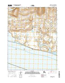
2016 Map of Noatak A-3 SE
USGS Topo · Published 2016About this map
Cape Krusenstern National Monument dominates this coastal landscape, protecting a significant expanse of northwestern Alaska's shoreline along the Kotzebue Sound. The terrain is characterized by complex hydrography, where the Situkuyok River winds through a vast network of wetlands and small ponds before reaching the coast. A prominent feature of the shoreline is the Aukulak Lagoon, which illustrates the transitional aquatic environment of the Chukchi Sea coast. This 2016 survey provides a detailed view of the natural drainage patterns and coastal lagoons that have long influenced the seasonal movements and subsistence practices of the region's inhabitants. The absence of roads or permanent settlements emphasizes the protected, wilderness character of this federal monument land.
Find a feature on this map
8 named features on this map. Tap any name to fly to it.
Don’t see what you’re looking for? This feature index may not catch every label — zoom into the map to look around manually.
Map Details
Editions of this 2016 Noatak A-3 SE Map
This is the sole edition of this map. No revisions or reprints were ever made.
Other maps of this area

1951 · Noatak
USGS Topo · 1:250,000

1951 · Kotzebue
USGS Topo · 1:250,000

1951 · Kotzebue D-2
USGS Topo · 1:63,360

1952 · Noatak A-3
USGS Topo · 1:63,360

1955 · Noatak
USGS Topo · 1:250,000
1955 · Noatak A-2
USGS Topo · 1:63,360

1958 · Kotzebue
USGS Topo · 1:250,000

1964 · Noatak
USGS Topo · 1:250,000

1964 · Kotzebue
USGS Topo · 1:250,000
2015 · Noatak A-3 NE
USGS Topo · 1:25,000