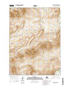
2014 Map of Noatak D-5 NW
USGS Topo · Published 2014About this map
The Asikpak River meanders across this northern landscape, defining the hydrology of the remote Northwest Arctic during this 2014 U.S. Geological Survey study. The terrain is dominated by the rising elevations of the Kitiram Ipitanga Hills, which provide a stark topographic contrast to the surrounding drainage basins. Smaller waterways like Tulukak Cr feed into the larger river systems, while the Kivalina River touches the southeastern reaches of the quadrangle. This map primarily serves to document the natural geography and watercourses in an area without permanent human settlements or infrastructure, focused instead on the raw elevation data and water flow patterns of the Alaskan arctic.
Find a feature on this map
8 named features on this map. Tap any name to fly to it.
Don’t see what you’re looking for? This feature index may not catch every label — zoom into the map to look around manually.
Map Details
Editions of this 2014 Noatak D-5 NW Map
This is the sole edition of this map. No revisions or reprints were ever made.
Other maps of this area

1951 · De Long Mountains
USGS Topo · 1:250,000

1951 · Noatak
USGS Topo · 1:250,000

1955 · Noatak
USGS Topo · 1:250,000

1955 · De Long Mountains
USGS Topo · 1:250,000

1955 · De Long Mountains A-4
USGS Topo · 1:63,360
1955 · Noatak D-6
USGS Topo · 1:63,360
1955 · Noatak D-5
USGS Topo · 1:63,360
1955 · De Long Mountains A-5
USGS Topo · 1:63,360

1964 · Noatak
USGS Topo · 1:250,000

1965 · De Long Mountains
USGS Topo · 1:250,000