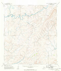
1955 Map of De Long Mountains A-5
USGS Topo · Published 1971About this map
The Kukpuk River winds through the northern landscape of this region, displaying a complex pattern of meanders and braided channels that characterize the Arctic coastal plain transition. Mapped by the U.S. Army Topographic Command in the early 1950s, the terrain is defined by high-elevation relief in the south, including the landmark of Kimikpak. In the southern portion of the quadrangle, the Singoalik River cuts through the rising foothills of the De Long Mountains. This area remains largely unsettled on the map, reflecting a remote wilderness landscape as it was documented just before the mid-century. The intricate contour lines illustrate a geography of sharp ridges and deep valleys, revealing the primary drainage basins that flow toward the Chukchi Sea.
Find a feature on this map
3 named features on this map. Tap any name to fly to it.
Don’t see what you’re looking for? This feature index may not catch every label — zoom into the map to look around manually.
Map Details
Editions of this 1955 De Long Mountains A-5 Map
This is the sole edition of this map. No revisions or reprints were ever made.
Other maps of this area

1951 · De Long Mountains
USGS Topo · 1:250,000

1951 · Noatak
USGS Topo · 1:250,000

1952 · Point Hope
USGS Topo · 1:250,000
1952 · Noatak D-7
USGS Topo · 1:63,360

1955 · Noatak
USGS Topo · 1:250,000

1955 · De Long Mountains
USGS Topo · 1:250,000

1955 · Point Hope
USGS Topo · 1:250,000

1955 · Point Hope A-1
USGS Topo · 1:63,360

1955 · Point Hope B-1
USGS Topo · 1:63,360

1955 · De Long Mountains A-4
USGS Topo · 1:63,360