
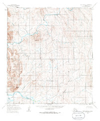
1955 Map of Point Hope B-1
USGS Topo · Published 1966About this map
The Ipewik River winds through the northwestern corner of this Arctic landscape, carving a path through the northern reaches of the Lisburne Hills. This 1955 survey by the Army Map Service reveals an unpopulated and roadless expanse, dominated by the drainage systems of the Kukpuk River and its many tributaries. The terrain is defined by prominent elevations such as Maktak Mountain and Angmakrok Mountain, which rise above the South Maktak Hills.
Find a feature on this map
13 named features on this map. Tap any name to fly to it.
Don’t see what you’re looking for? This feature index may not catch every label — zoom into the map to look around manually.
Map Details
Editions of this 1955 Point Hope B-1 Map
2 editions found
Other maps of this area

1951 · De Long Mountains
USGS Topo · 1:250,000

1952 · Point Hope
USGS Topo · 1:250,000

1952 · Point Hope A-2
USGS Topo · 1:63,360

1955 · De Long Mountains
USGS Topo · 1:250,000

1955 · Point Hope
USGS Topo · 1:250,000

1955 · Point Hope C-1
USGS Topo · 1:63,360

1955 · Point Hope A-1
USGS Topo · 1:63,360

1955 · Point Hope C-2
USGS Topo · 1:63,360

1955 · Point Hope B-2
USGS Topo · 1:63,360
1955 · De Long Mountains A-5
USGS Topo · 1:63,360