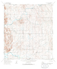
1955 Map of Point Hope B-1
USGS Topo · Published 1986About this map
The Kukpuk River and Ipewik River define the hydrography of this Arctic coastal plain landscape, winding through a series of isolated mountain ranges and foothills in Northwest Alaska. Surveyed by the Army Map Service in the mid-1950s, the terrain is characterized by the Lisburne Hills and the prominent Shakpik Mountain to the west. The area's geological character is hinted at by features such as Phosphorite Creek, while the drainages of Saligvik Valley and Kakpeyak River illustrate the complex watershed patterns of the North Slope. Between the major river systems lie the South Maktak Hills and Maktak Mountain, landmarks that served as vital navigation points for those traversing the tundra before modern infrastructure. This 1:63,360 scale study provides a detailed record of the landforms and indigenous-named watercourses as they were documented during the Cold War era.
Find a feature on this map
14 named features on this map. Tap any name to fly to it.
Don’t see what you’re looking for? This feature index may not catch every label — zoom into the map to look around manually.
Map Details
Editions of this 1955 Point Hope B-1 Map
2 editions found
Other maps of this area

1951 · De Long Mountains
USGS Topo · 1:250,000

1952 · Point Hope
USGS Topo · 1:250,000

1952 · Point Hope A-2
USGS Topo · 1:63,360

1955 · De Long Mountains
USGS Topo · 1:250,000

1955 · Point Hope
USGS Topo · 1:250,000

1955 · Point Hope C-1
USGS Topo · 1:63,360

1955 · Point Hope A-1
USGS Topo · 1:63,360

1955 · Point Hope B-1
USGS Topo · 1:63,360

1955 · Point Hope C-2
USGS Topo · 1:63,360

1955 · Point Hope B-2
USGS Topo · 1:63,360