
1955 Map of Point Hope C-2
USGS Topo · Published 1966About this map
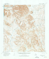
The Lisburne Hills dominate this coastal Alaskan landscape, where the high ridges of the Brooks Range meet the shoreline of the Chukchi Sea. Prominent peaks like Mount Buckland and Mount Itsalik anchor a complex system of drainages, where the topography was mapped by the Army Map Service using mid-century photogrammetric methods. The map reveals an intricate network of waterways, including Ukinyak Creek in the north and the southward-flowing Kugururok Creek, illustrating the natural drainage patterns that define this Arctic environment. With no settlements or roads shown, the map serves as a study of the untouched geography of the North Slope in the 1950s, documenting named peaks such as Angayutak Mountain and Iviangik Mountain alongside traditional watercourse names like Akatolik Creek and Tungnak Creek.
Find a feature on this map
13 named features on this map. Tap any name to fly to it.
Don’t see what you’re looking for? This feature index may not catch every label — zoom into the map to look around manually.
Map Details
Editions of this 1955 Point Hope C-2 Map
2 editions found
Other maps of this area

1952 · Point Hope
USGS Topo · 1:250,000

1952 · Point Hope B-3
USGS Topo · 1:63,360
1952 · Point Hope C-3
USGS Topo · 1:63,360

1952 · Point Hope D-1
USGS Topo · 1:63,360

1952 · Point Hope D-2
USGS Topo · 1:63,360

1955 · Point Hope
USGS Topo · 1:250,000

1955 · Point Hope C-1
USGS Topo · 1:63,360

1955 · Point Hope B-1
USGS Topo · 1:63,360

1955 · Point Hope B-2
USGS Topo · 1:63,360

1965 · Point Hope
USGS Topo · 1:250,000