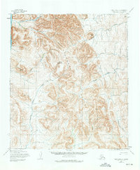
1955 Map of Point Hope C-2
USGS Topo · Published 1975About this map
The Lisburne Hills and the western reaches of the De Long Mountains dominate this 1955 topographic study of the Alaska coast. This landscape is defined by the drainage systems of the Kukpuk River and the Kivalina River, which carve through high peaks such as Mount Buckland and Mount Itsalik. Along the western edge, the coastline meets the Chukchi Sea, where Ukinyik Creek flows into the arctic waters.
Find a feature on this map
13 named features on this map. Tap any name to fly to it.
Don’t see what you’re looking for? This feature index may not catch every label — zoom into the map to look around manually.
Map Details
Editions of this 1955 Point Hope C-2 Map
2 editions found
Other maps of this area

1952 · Point Hope
USGS Topo · 1:250,000

1952 · Point Hope B-3
USGS Topo · 1:63,360
1952 · Point Hope C-3
USGS Topo · 1:63,360

1952 · Point Hope D-1
USGS Topo · 1:63,360

1952 · Point Hope D-2
USGS Topo · 1:63,360

1955 · Point Hope
USGS Topo · 1:250,000

1955 · Point Hope C-1
USGS Topo · 1:63,360

1955 · Point Hope B-1
USGS Topo · 1:63,360

1955 · Point Hope C-2
USGS Topo · 1:63,360

1955 · Point Hope B-2
USGS Topo · 1:63,360