
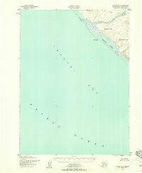
1955 Map of Point Hope A-1
USGS Topo · Published 1966About this map
The Chukchi Sea coastline and the meandering Kukpuk River define this mid-century Alaskan landscape, which was mapped by the Army Map Service using 1952 aerial photography. A prominent Winter Trail skirts the southern edge of the terrain, connecting the coastal lagoons such as Atosik Lagoon and Mapsorak Lagoon to the inland ridges. The interior is dominated by significant elevations including Kisimilok Mountain and Sakolik Mountain, separated by high-relief features like Battery Ridge and Sigrikpak Ridge. The presence of the Alolukrok (Site) suggests a location of human activity or seasonal occupation along the river's path, while various waterways like Phosphorite Creek and Niyikluk Creek drain the complex topographic heights toward the sea.
Find a feature on this map
22 named features on this map. Tap any name to fly to it.
Don’t see what you’re looking for? This feature index may not catch every label — zoom into the map to look around manually.
Map Details
Editions of this 1955 Point Hope A-1 Map
This is the sole edition of this map. No revisions or reprints were ever made.
Other maps of this area

1951 · De Long Mountains
USGS Topo · 1:250,000

1951 · Noatak
USGS Topo · 1:250,000

1952 · Point Hope
USGS Topo · 1:250,000
1952 · Noatak D-7
USGS Topo · 1:63,360

1952 · Point Hope A-2
USGS Topo · 1:63,360

1955 · Noatak
USGS Topo · 1:250,000

1955 · De Long Mountains
USGS Topo · 1:250,000

1955 · Point Hope
USGS Topo · 1:250,000

1955 · Point Hope B-1
USGS Topo · 1:63,360

1955 · Point Hope B-2
USGS Topo · 1:63,360