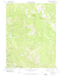
1969 Map of Noble Butte
USGS Topo · Published 1974About this map
Red Mountain dominates this corner of Mendocino County, where the South Fork Eel River carves a deep valley through the coastal ranges. In the late 1960s, this landscape was defined by its protected old-growth timber and small riverside settlements like Riverdale and Bridges. The map details the Smithe State Park and the Standish-Hickey State Recreation Area, noting landmarks such as the Capt Miles Standish Tree and the Dora Redwoods Reserve.
Find a feature on this map
50 named features on this map. Tap any name to fly to it.
Don’t see what you’re looking for? This feature index may not catch every label — zoom into the map to look around manually.
Map Details
Editions of this 1969 Noble Butte Map
2 editions found
Other maps of this area

1920 · Cummings
USGS Topo · 1:62,500

1920 · Harris
USGS Topo · 1:62,500

1921 · Briceland
USGS Topo · 1:62,500

1949 · Alderpoint
USGS Topo · 1:62,500

1949 · Garberville
USGS Topo · 1:62,500

1950 · Piercy
USGS Topo · 1:62,500

1951 · Alderpoint
USGS Topo · 1:62,500

1951 · Garberville
USGS Topo · 1:62,500

1952 · Leggett
USGS Topo · 1:62,500

1957 · Ukiah
USGS Topo · 1:250,000