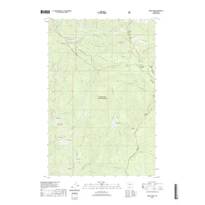
2020 Map of Noble Knob
USGS Topo · Published 2020About this map
Snoqualmie National Forest dominates this high-elevation landscape at the intersection of King, Pierce, Kittitas, and Yakima counties. The terrain is defined by a network of historic transit routes, including the legendary Pacific Crest National Scenic Trail and the Greenwater Trail, which follow the deep valleys and ridgelines of the Cascade Range. Central to the map is the prominent peak of Noble Knob, surrounded by a series of alpine water bodies such as Lost Lake, Quinn Lake, and Echo Lake. The prominence of Government Meadow and Naches Pass highlights the importance of these gaps for early trans-mountain travel. Further south, the map reveals the rugged ascent to Corral Pass and the rocky summits of Mutton Mtn and Arch Rock. The drainage patterns are clearly marked by the Greenwater River and the S Fork Little Naches River, which carve through the dense timberlands and provide the primary hydrographic framework for the region.
Find a feature on this map
49 named features on this map. Tap any name to fly to it.
Don’t see what you’re looking for? This feature index may not catch every label — zoom into the map to look around manually.
Map Details
Editions of this 2020 Noble Knob Map
This is the sole edition of this map. No revisions or reprints were ever made.
Other maps of this area

1901 · Snoqualmie Pass
USGS Topo · 1:125,000

1902 · Mount Aix
USGS Topo · 1:125,000

1903 · Snoqualmie
USGS Topo · 1:125,000

1904 · Mt Aix
USGS Topo · 1:125,000

1913 · Cedar Lake
USGS Topo · 1:125,000

1924 · Mt Rainier
USGS Topo · 1:96,000

1928 · Mt Rainier
USGS Topo · 1:125,000

1950 · Yakima
USGS Topo · 1:250,000

1956 · Greenwater
USGS Topo · 1:62,500

1957 · Wenatchee
USGS Topo · 1:250,000